10 Moderate Hikes

Mount Diablo State Park
Ten Moderate Hikes
Frank Valle-Riestra
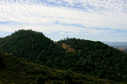
You are invited to explore ten of the mountain's most attractive environments, some not all that well known, along trails that are not particularly difficult. The hikes outlined below are no more than half-day walks, from two to four hours or so long. However, you may face some stiff climbs—none of them long—and good boots are strongly recommended, for some of the trails are a bit rough.
With a few exceptions, there is no potable water on these trails. You should carry drinks with you. Many of the trails are narrow and you may run across poison oak. If you think you are susceptible, it is best to protect your limbs with appropriate clothing. Such protection also comes in handy in keeping away ticks that, let's face it, are around. Keep in mind that in summer the mountain gets pretty hot in the sun, so carry some headgear. In other seasons, carry at least a light jacket to ward off chill winds that can arise suddenly.
The Trail Map of Mount Diablo State Park and the Hikers Guide to Mount Diablo State Park are available at the MDIA Online Store as well as other interesting publications and items related to Mount Diablo. The trail map is also available at either the North Gate or South Gate Entrance Stations, the Summit Visitor Center, and the Mitchell Canyon Visitor Center. Also, be sure you know how to read trail signs on Mount Diablo.
3 cups
Blueberries
Mount Diablo State Park
Ten Moderate Hikes
Frank Valle-Riestra
You are invited to explore ten of the mountain's most attractive environments, some not all that well known, along trails that are not particularly difficult. The hikes outlined below are no more than half-day walks, from two to four hours or so long. However, you may face some stiff climbs—none of them long—and good boots are strongly recommended, for some of the trails are a bit rough.
With a few exceptions, there is no potable water on these trails. You should carry drinks with you. Many of the trails are narrow and you may run across poison oak. If you think you are susceptible, it is best to protect your limbs with appropriate clothing. Such protection also comes in handy in keeping away ticks that, let's face it, are around. Keep in mind that in summer the mountain gets pretty hot in the sun, so carry some headgear. In other seasons, carry at least a light jacket to ward off chill winds that can arise suddenly.
The Trail Map of Mount Diablo State Park and the Hikers Guide to Mount Diablo State Park are available at the MDIA Online Store as well as other interesting publications and items related to Mount Diablo. The trail map is also available at either the North Gate or South Gate Entrance Stations, the Summit Visitor Center, and the Mitchell Canyon Visitor Center. Also, be sure you know how to read trail signs on Mount Diablo.
Trail Name | Scenic Views | Wildflowers | Riparian | Flora | Birds | History | Fauna | Butterflies | Geology Interest |
|---|---|---|---|---|---|---|---|---|---|
Fall Trails Loop | X | X | X | ||||||
Mount Olympia via North Peak | X | X | X | ||||||
Twin Peaks - Mitchell Rock | X | X | X | X | |||||
Black Point Loop | X | X | X | ||||||
Balancing Rock - Knobcone Pt | X | X | X | X | |||||
Chase Pond - Hidden Pond | X | X | X | ||||||
Dan Cook Canyon | X | X | X | ||||||
Eagle Peak | X | X | X | X | |||||
Sycamore Canyon Loop | X | X | X | ||||||
Olofson Ridge | X | X | X | X |
TRAILHEAD:
End of paved part of Mitchell Canyon Road, north entrance to park, near the town of Clayton. Park in staging area (water and toilets). $6 parking fee.
TRAIL
STATISTICS:
From the trailhead, walk a short distance and turn left on Oak Road, left to stay on Oak Road, and then right on Murchio Road. Turn right on Donner Canyon Road up to Cardinet Oaks Road to the Falls Trail returning loop back via Middle Trail, briefly right on Meridian Ridge Road, then back left down Donner Canyon Road. In winter and early spring, roads at lower elevations may be muddy.
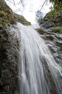
DESCRIPTION: In winter (rainy season) and throughout spring, the Falls Trail offers fine views of the mountain's most spectacular attraction, several waterfalls up to 100 feet high. Spring also brings astounding displays of wildflowers, and the colorful rock formations are worth the trip at any time. Kindly refrain from scrambling down to the falls; it is dangerous and damages the landscape.
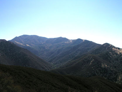
Mount Olympia via North Peak
2
TRAILHEAD:
At roadside parking area. Devil’s Elbow, on Summit Road, just below the summit. Facilities at summit.
TRAIL
STATISTICS:
This is a 4.6 miles round trip on North Peak Trail and to Prospector's Gap, then continuing on North Peak Road to the top. The descent from North Peak to Mount Olympia is very steep, on slippery scree. After leaving North Peak, turn right on North Peak Trail to the Olympia Summit. Round trip involves a total climb of 1,670 feet, mostly on the way back.
DESCRIPTION: This is a trip for those who enjoy an unlimited sky above and views into distant depths below. The one-track path to Prospector’s Gap is a showplace for wildflowers in the spring. Mount Olympia, itself, is like a little throne high above the encircling landscape, where you can sit and observe the puny world below you, and beyond, the great plains of the Central Valley. In wintertime, the mists rolling up from the depths of Donner Canyon put on a great show of landscape hide-and-seek.
Twin Peaks - Mitchell Rock Loop
3
TRAILHEAD:
End of paved part of Mitchell Canyon Road, north entrance to park, near the town of Clayton. Park in staging area (water and toilets). $6 parking fee.
TRAIL
STATISTICS:
A 4-mile loop incorporating Coulter Pine, Eagle Peak, and Mitchell Rock Trails. Take Mitchell Canyon Road to Oak Road to Coulter Pine Trail to find the Eagle Peak Trail; its beginning may be a little faint, leading uphill opposite a downed oak tree. The trail parallels Back Creek and climbs gently up toward Twin Peaks. Climb of 1,100 feet. At the junction head back down to the right on the lovely Mitchell Rock Trail with stops at the Peaks and the Rock itself.

DESCRIPTION: This is a wonderfully scenic loop at any time of year, passing through several distinct habitat zones -- meadow lands, oak savannah, chaparral, rocky summits, and a fine stand of Coulter pines. The Eagle Peak Trail climbs steadily to meet the Mitchell Rock Trail at the crest of Twin Peaks. Visitors have forged a maze of informal trails, but stick to the crest to descend, to the lower Twin Peak, and you won't have any trouble. Pause to admire the brilliantly colored rocks at the venerable Great-Berried manzanita, survivors of many fires, with exquisite blooms in January and February. Take care -- Twin Peaks have dangerous vertical drop-offs! When Mitchell Rock Trail changes into a fire road entering the bottom meadows, veer left back to the trailhead.
Black Point Loop
4
TRAILHEAD:
End of paved part of Mitchell Canyon Road, north entrance to park, near the town of Clayton. Park in staging area (water and toilets). $6 parking fee.
TRAIL
STATISTICS:
The Black Point Trail proper starts about one-half mile along the Mitchell Canyon Road trail, on the right just beyond the creek crossing. It ends on Red Road and the loop is completed by taking Mitchell Canyon Road back to the trailhead -- or better yet by taking the small Globe Lily Trail which parallels the road. The loop is 4.8 miles long, and the climb is 1,190 feet.
DESCRIPTION: An outstanding journey through a hidden, little-known corner of the park, spanning several life zones, culminating at the chaparral-covered summit of Black Point. From here a truly unique perspective of central Contra Costa is obtained. Watch for evidence of mining trailside during descent from Black Point. The return trail paralleling Mitchell Canyon Road in spring, shelters fine displays of the endemic Mount Diablo globe lily in good years. Wear light-colored protective clothing to combat ticks.
Balancing Rock and Knobcone Point
5
TRAILHEAD:
Paved parking pull-out at Curry Point, South Gate Road. No facilities.
TRAIL
STATISTICS:
4.5 miles round trip, level except for a few ups and downs. Easy walk.
DESCRIPTION: Knobcone Point Road follows the crest of the tilted strata of Domengine sandstone, culminating with the teetering wall known as Balancing Rock. This feature has been faithfully reproduced on a full scale and forms the display focus at Walnut Creek's Lindsay Wildlife Experience Museum. Beyond Balancing Rock, and just before the park boundary gate, follow the spur road to the right; this takes you to a most interesting display of the beneficial effect of fire (this one in 1981) upon the regeneration of knobcone pines. A controlled burn of underbrush was done in 1995. At the end of the spur, to the right of the transmission line pylons, stop to admire the incredibly complex eroded sandstone landscape and the resident turkey vultures perched there or soaring overhead. Do not attempt to scale the dangerous cliffs, tempting as that may be -- respect the privacy of the ticks and rattlesnakes.

Chase Pond and Hidden Pond
6
TRAILHEAD:
Paved parking pull-out at Curry Point, South Gate Road. No facilities.
TRAIL
STATISTICS:
5.8 miles mostly on dirt roads, but about 0.8 miles cross-country. Total climb of 1170 feet.

DESCRIPTION: The trails up to the twin Chase Ponds are well-marked at intersections. The first section down Curry Canyon Road passes through a beautiful, shaded strip of riparian vegetation. A turn onto Frog Pond Road opens up rolling grasslands with some of the finest displays of massed wildflowers in the spring. Just beyond Chase Pond, the road turns uphill and becomes quite faint -- follow it until it meets Mountain Springs Creek, where an old cow-crossing facilitates the climb up the opposite bank. Now turn back and walk cross-country in the general direction of Hidden Pond. Easily spotted among the grassy knolls, Hidden Pond is one of the mountain’s beauty spots -- a peaceful, lonesome pond, the quiet waters reflecting overhanging branches, the great mountain looming up behind. A short cross-country jaunt brings you to Frog Pond Road for the trip back.
Dan Cook Canyon
7
TRAILHEAD:
From Southgate Road, park in the Rock City area. From here walk down the access road to Live Oak Campground heading straight down onto Summit Trail. There is no day parking at the campground.
TRAIL
STATISTICS:
3.2 miles round trip to Live Oak Campground on first part of the Summit Trail. 730-ft. climb.
DESCRIPTION: A trail for tree lovers and rock lovers, and a great favorite for mountain bikers. It will he hard for you to resist exploring the maze of Rock City with its fascinating vistas of grotesquely eroded sandstone pinnacles and wind caves, but make your way down to the campground. The environment varies from a shady canyon of maples, sycamores, alders, and bay trees to a dry oak savannah.
Eagle Peak
8
TRAILHEAD:
There is a large parking area at the Diablo Overlook on Summit Road just at the entrance to Juniper Campground. Walk to the end of the campground and find the trail across from the restrooms. Facilities in the campground.
TRAIL
STATISTICS:
6.3 miles out and back via Deer Flat Road, Meridian Ridge Road, and Eagle Peak Trail. Total climb of 1,490 feet.

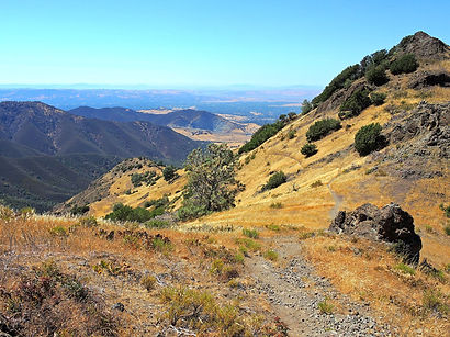
DESCRIPTION: This hike, has everything, starting with the flower-strewn meadows going down to Deer Flat. Deer Flat, itself, with its symphony of bird song, is one of the mountain's memorable beauty spots. Eagle Peak Trail is an exciting hogback, often only a few feet wide, with sharp drop-offs on each side. Eagle Peak is a rocky belvedere from which to admire the expanse of Contra Costa’s "Central Valley" before you -- a good place to pause for lunch.
Sycamore Canyon Loop
9
TRAILHEAD:
Paved parking pull-out at Curry Point, South Gate Road. No facilities.
TRAIL
STATISTICS:
3.4-mile loop using Knobcone Point, Black Hawk Ridge, and Sycamore Creek Roads then Devil's Slide trail back to Knobcone Point Trail. 580-ft. climb on the return loop.

DESCRIPTION: A hike to savor the colors of fall or the fog-softened mysteries of winter. The passing scene is endlessly surprising and refreshing. Initially, you walk through rolling meadows with magnificent views of the Mount Diablo massif above Curry, seen through the branches of stately oaks, which, in foggy weather assume a wonderful ghost-like appearance. On clear winter days, the snowy crest of the Sierra Nevada may he admired, far beyond the great expanse of the Central Valley: The colorful leafy carpets under towering sycamore trees, deep down in Sycamore Canyon, are unforgettable. Your climb back on Devil's Slide is a lovely one along a babbling brook, let your nose guide you to a stop at the peculiar Sulfur Spring.
Olofson Ridge
10
TRAILHEAD:
End of paved part of Mitchell Canyon Road, north entrance to park, near the town of Clayton. Park in staging area (water and toilets). $6 parking fee.
TRAIL
STATISTICS:
5.3-mile round trip. 1,010-ft. climb.
DESCRIPTION: After just one mile along beautiful Mitchell Canyon, turn right on Red Road which, incongruously, climbs White Canyon. In springtime, this is the site of rarer wildflower species such as the Mount Diablo Globe Lily and Wind Poppies. Take a sharp left onto Olofson Ridge Trail and climb to the boundary gate. Just before the gate follow a faint trail on the left toward the summit. Find yourself a perch on one of the cherty outcrops whitewashed by the presence of fellow raptors, and lose yourself in the world of hawks, kestrels, and turkey vultures. With the awesome chasm of Mitchell Canyon and the massive walls of Eagle Peak as a background, admire the aerial acrobatics of these magnificent fliers -- with luck, you may even spot a golden eagle.